
Spatial intelligence, documented.
Document the site as it stands. Keep a clear record as it changes.
LiDAR scanning and documentation for commercial projects across the GTA, Hamilton, Niagara and across Ontario.
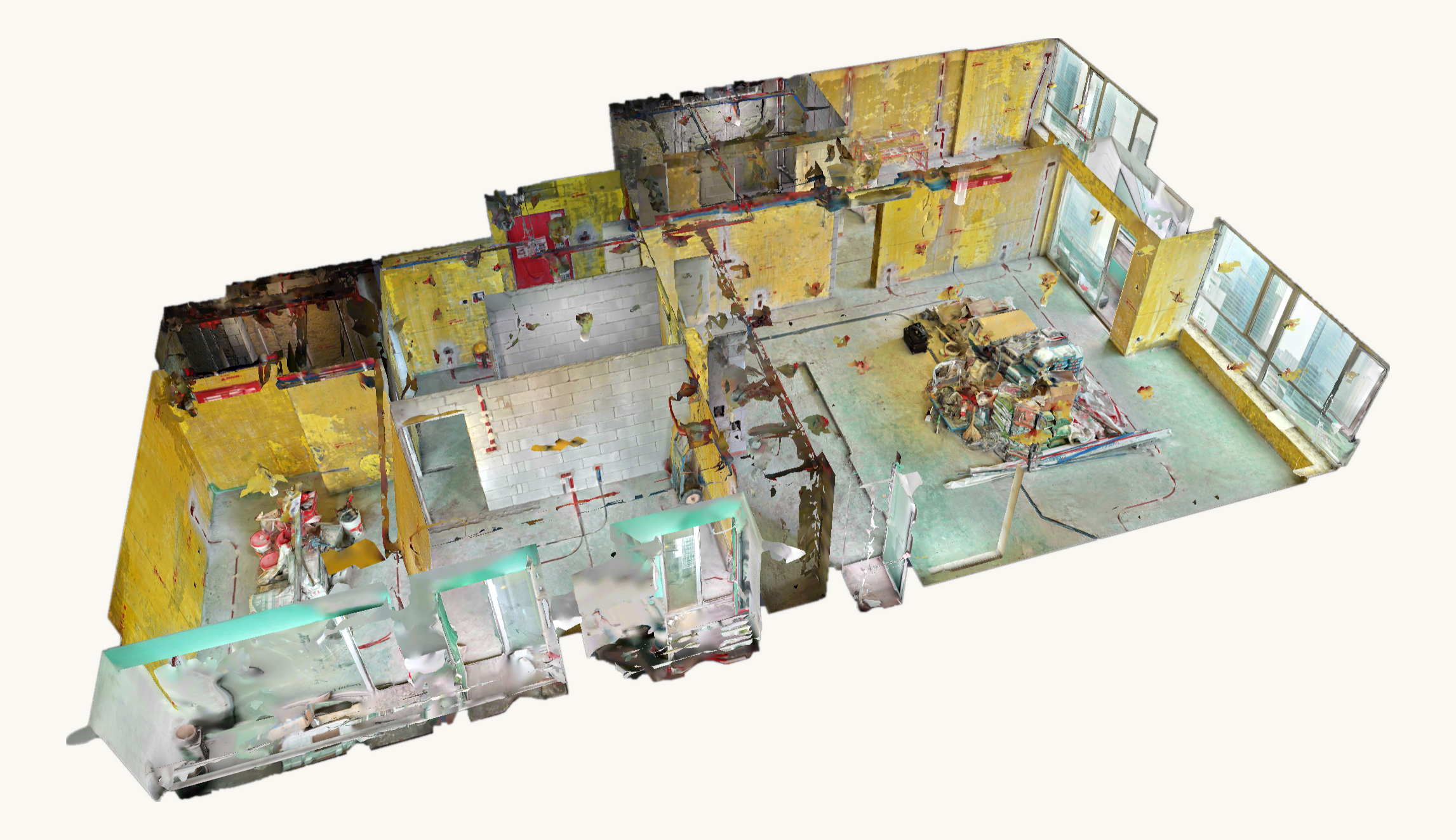
Sample LiDAR scan, 3D overview · SAMPLE / TEST DATA
Built Spatial is a documentation partner that captures, organizes and interprets site conditions through the project lifecycle.
The problem we solve
When the record is missing, someone pays for it.
Hidden services, disputed conditions and unknown spaces cost time and money. We capture the space once, so later decisions can rest on documented conditions.
For general contractors and builders
Closed walls shouldn’t mean lost information.
We record existing conditions, rough-in before close-up, progress and handover. Your team, the owner and the next trade can review visible conditions recorded at the time of capture, with less need to open walls or dispute existing conditions.
What you receive
Measured, labelled and ready to use
Each record identifies what was there and where: widths, heights and clearances measured with stated tolerances, and services tagged before they are concealed. Select the image to open it at full size.
For owners, brokers and insurers
Support claims with documented pre-loss conditions.
We make a dated baseline of the commercial space and its contents before anything happens, update it each year, and capture the space after a loss. The adjuster then starts from a dated, documented record.
For property managers
Fit-outs supported by documented existing conditions.
We produce unit turnover records, a Fit-Out Readiness Pack for the next tenant’s designer and GC, and a baseline of common areas. That can mean fewer site visits and fewer surprises at turnover.
Sample LiDAR scan · annotated view · SAMPLE / TEST DATA
A record you can reuse
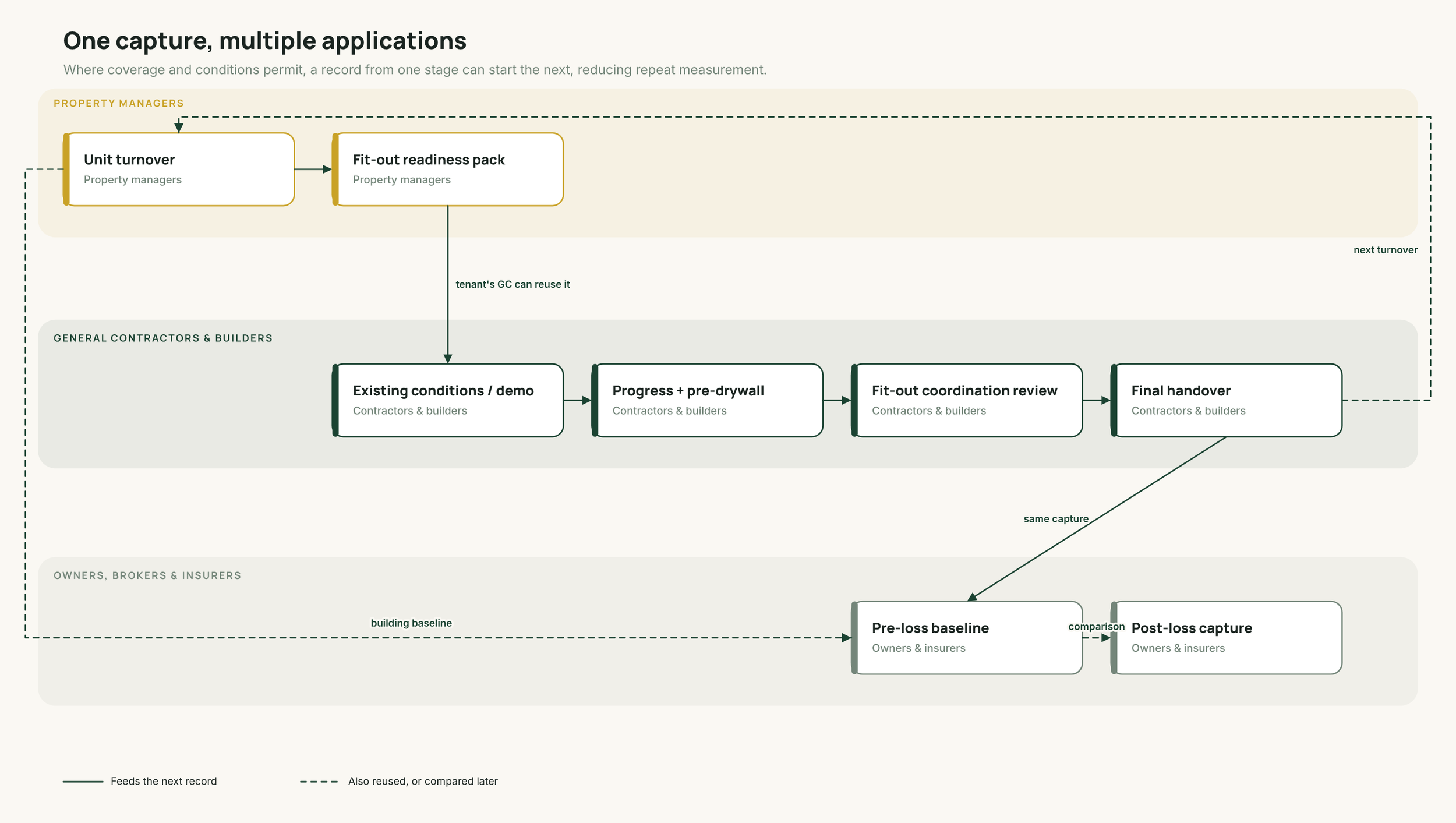
One capture, multiple applications
Where coverage and conditions permit, a single capture can be reused. The record from one stage can become the starting point for the next, reducing repeat measurement of the same space.
Property managers: a unit turnover record becomes the starting point for the next fit-out. The Fit-Out Readiness Pack provides the incoming tenant’s designer and GC with documented conditions, and can lead directly into a Fit-Out Coordination Review.
Owners: a final handover record already holds the 3D virtual tour, point cloud, plan and finishes register, which can form much of a pre-loss baseline. It can support the insurance file, often without another site visit.
Buildings: one baseline of common areas, lobbies and service rooms can serve both the property manager and the insurer.
Every capture is a LiDAR scan saved as an E57 point cloud with high-resolution panoramas and a 3D virtual tour, with machine-assisted review, checked by a person before anything goes out.
Roles served
One shared record for the whole project team
A single capture serves each role on the project, reducing site walks, information requests and disputes over existing conditions.
Superintendent
Checks what was installed and when, and resolves questions about site conditions without a return visit.
Project manager
Has a dated progress record ready for meetings, pay applications and fabrication releases.
Architect
Starts design from documented existing conditions and reviews what was built before it is closed in.
Owner
Receives a navigable record of the completed space, with plans and a finishes register, at handover.
Insurer
Has a dated pre-loss baseline of the commercial space on file, and a clear comparison after a loss.
Property manager
Keeps condition records at each change of tenant and gives the next tenant’s team a starting point.
How it works
From enquiry to a usable record
01
Define the information required
Share the space, the project stage and the questions the record must answer. We plan the visit around what must be captured while it is still visible.
02
A complete capture, planned around your schedule
We scan the space with LiDAR and 360 panoramas with minimal disruption to the site. Conditions missed on the day cannot be captured once they are closed in or cleared away, so coverage is the priority.
03
Reviewed deliverables, not raw data
Machine-assisted review, checked by a person, turns the scan into the 3D virtual tour, files and notes for your service, ready to share with your team.
Establish the record before it is needed.
Share the site, the project stage and the information you need. We will reply with next steps and a proposed capture date.